UK VFR briefing without the tab overload.Free NOTAMs to start. Pro workflow when you need more.
VFR Wise UK brings together free NOTAM access, Student Hub guidance, pilot tools, and a Pro briefing workflow for UK VFR flying, so you spend less time stitching information together and more time making a sound pre-flight decision.
Pilot Briefing
Pull local NOTAMs, frequencies, daylight, runway detail, and weather into one home-airfield briefing instead of checking five separate places.
AI NOTAM Briefing
Turn dense UK notices into plain-English operational impact so you stop wasting time decoding what actually matters.
Runway and low-level weather
Check likely runway fit, surface wind, and 2,000 ft conditions before you set off for the airfield and find the plan no longer works.
Airspace and navigation data
View UK airspace on the map and browse navaids, VRPs, and aerodrome reference without jumping between sites or PDFs.
Fuel and planning tools
Check fuel margin, compare weather, and work through practical planning tools without losing the thread halfway through briefing.
Should I Fly?
A fun quick check on today’s conditions that is easy to share if you are deciding whether to fly with friends.
Free to start
Basic NOTAM access, Student Hub, METAR and TAF decoders, plus RT practice tools.
Live Briefing Example
From raw NOTAM to practical pilot briefing in one view
Start with the official notice, then move straight into a clearer read on what it changes for a UK VFR flight. That means less time decoding and less chance of missing something important.
Raw NOTAM
M1708/26
Q) EGTT/RMCA/IV/BO/W/195/660/5240N00424W053
A) EGTT
B) 2603040745
C) 2603041800
E) THE FOLLOWING NORTH WALES MILITARY TRAINING AREAS ACTIVATED:
NORTH LOW 0745-1030 FL195-FL285
NORTH LOW 1030-1300 FL195-FL285
NORTH LOW 1300-1530 FL195-FL285
NORTH LOW 1530-1800 FL195-FL285
NORTH HIGH 1300-1430 FL285-FL660
SOUTH LOW 0745-1030 FL195-FL285
SOUTH LOW 1030-1300 FL195-FL285
SOUTH LOW 1300-1530 FL195-FL285
SOUTH LOW 1530-1800 FL195-FL285
SOUTH HIGH 1300-1430 FL285-FL660
F) FL195
G) FL660
AI Summary
Raw METAR
METAR EGBB 240820Z 22009KT 170V250 9999 BKN011 11/08 Q1012
Readable version
Wind 220 degrees true, 9 kt, varying 170 to 250 degrees, visibility 10 km or more, broken (5-7 oktas) at 1,100 ft above airfield, temperature 11 C, dew point 8 C, QNH 1012 hPa.
Briefing priorities
Weather
Good VFR
Visibility
10 km+
Wind at 2,000 ft
220° / 9 kt
NOTAM review
3 nearby
What you spot faster
Weather, wind, runway suitability, and NOTAMs are surfaced in one view instead of spread across tabs and PDFs.
What this saves
Less rereading, less copy-and-paste, and less second-guessing whether you have actually understood the report properly.
Why people upgrade
Because the value is not more data. It is getting to the important operational picture sooner, with less effort.
Start free. Upgrade when you want the full briefing workflow.
Keep free access for learning and basic checks, then move to Pro when you want the faster, deeper pre-flight picture for UK VFR flying and less wasted briefing time.
Free
A strong free starting point for students and UK VFR pilots who want the essentials
- Basic NOTAM list and map view
- Filter by aerodrome and radius
- Raw NOTAM text access
- Student Hub and free pilot tools
- AI briefing summaries
- Pilot Briefing and weather workspace
- Fuel planning and aerodrome directory
Pro
The faster briefing and planning workflow for UK VFR pilots who want the important bits surfaced quickly
- Everything in Free
- Full AI briefing summaries and impact tagging
- Pilot Briefing with runway and weather context
- Weather workspace, fuel planning, airspace map, and aerodrome directory
- Briefing report export (PDF)
- NOTAM version and change history
Membership that earns its keep
An effortless briefing workflow that earns its keep
Briefing should feel effortless, not like stitching together tabs, PDFs, weather pages, and screenshots. VFR Wise helps you understand the NOTAM picture sooner, compare weather properly, check runway fit, confirm fuel margin, and brief your home airfield from one place. If you currently brief by hopping between apps and websites, this is the time you get back.
AI-decoded NOTAMs with operational context
Nearby NOTAM watchlist so local changes stand out quickly
METAR, TAF, and weather comparison workspace
Runway alignment suggestions and low-level forecast cues
Fuel planning with visible margin and steps
Airspace map with navaid and VRP data
Aerodrome directory and reference pages
Flight calculators for speed, distance, and conversions
Free still matters
Plenty to use free before you upgrade
Student Hub
Free UK-focused guidance from first lesson to skill test, written for real training journeys in club aircraft.
Basic NOTAM access
Open the NOTAM list and map, filter by aerodrome or radius, and review the raw notice data for free.
Should I Fly?
A fun quick conditions check you can share if you and your friends are deciding whether today still works for flying.
METAR Decoder
Decode METAR observations into plain language before the weather becomes another tab to interpret.
TAF Decoder
Understand forecast change groups and timing faster when you are planning a local sortie or cross-country.
Radio Call Builder
Practise CAP 413-style call flow and readbacks before you key the mic for real.
Also from VFR Wise
Mobile apps for pilots worldwide
The same team behind the UK briefing service builds mobile apps for flight planning and calculations — available worldwide, no internet required.
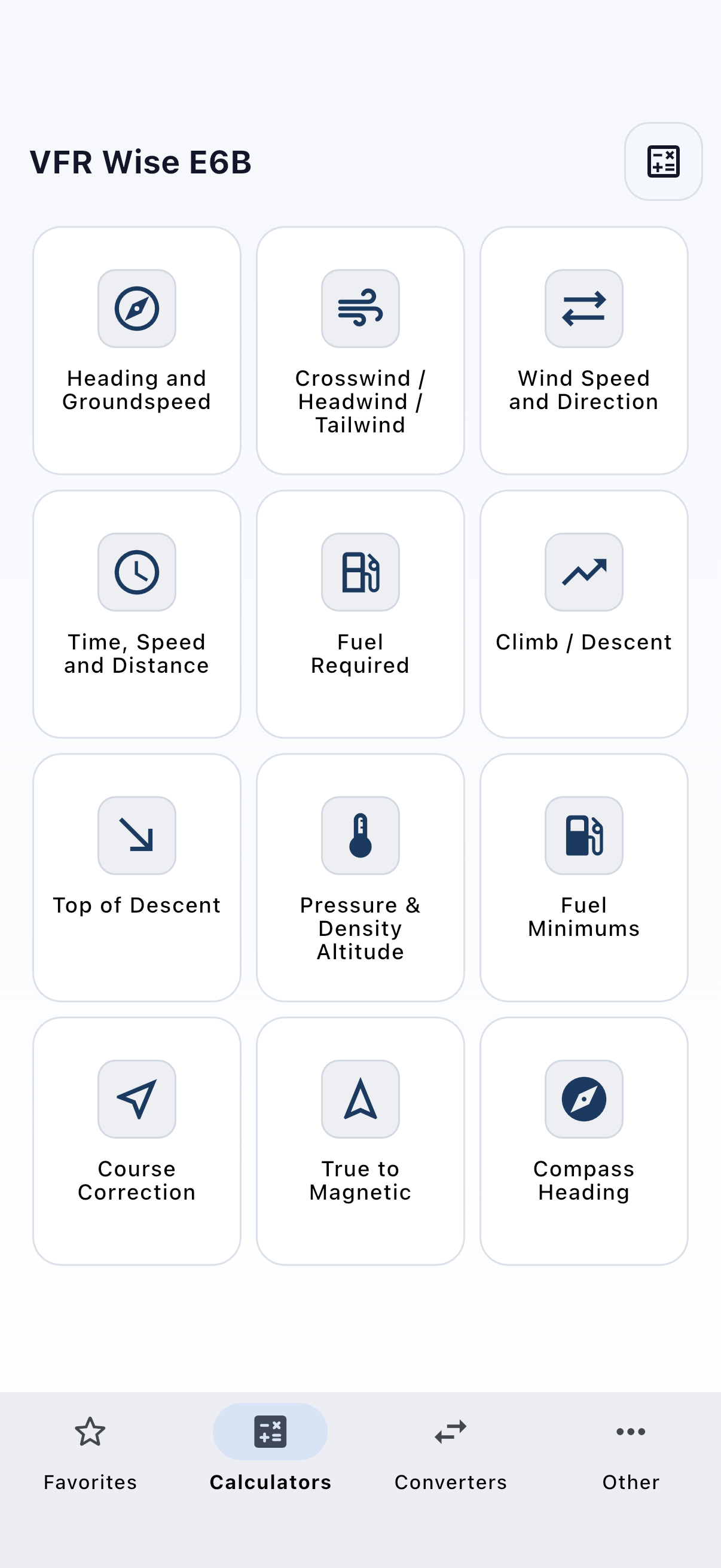
VFR Wise E6B
Quick answers without bouncing between separate tools.
A mobile app with all your flight planning calculators in one place — wind correction, headings, fuel, time, and unit conversions. No internet needed, works anywhere in the world.
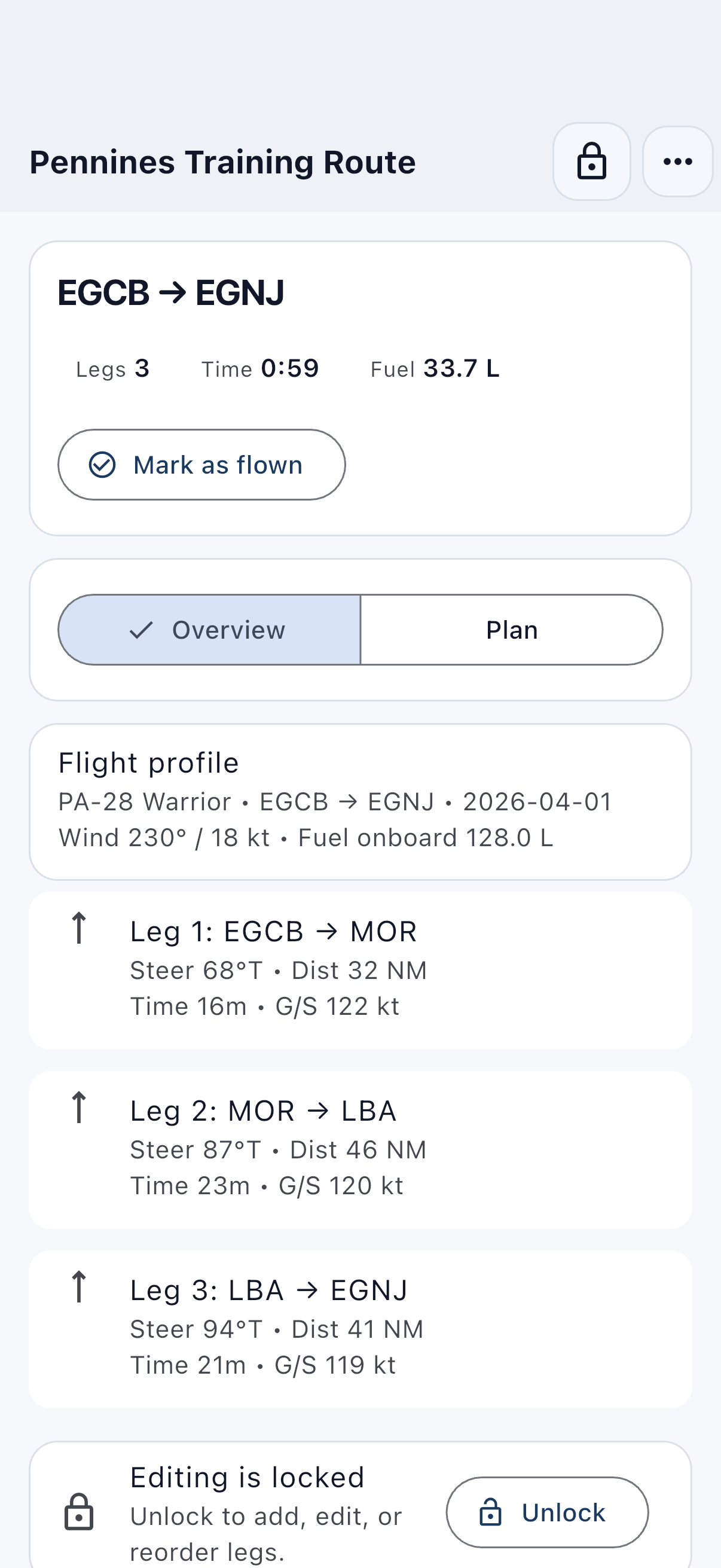
VFR Wise Nav Log
Plan the route and keep the working details in one place.
A mobile app for multi-leg VFR flight planning. Build your nav log, track legs and timings, and keep the whole plan in one tidy workflow — no more piecing it together by hand.